After lobbying the state to change name of a ferry terminal, Coupeville leaders want to change signs to show tourists a faster way to drive to town.
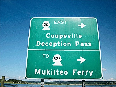
A sign in front of the Coupeville (formerly Keystone) ferry terminal exit near Fort Casey State Park directs motorists to turn right to get to Coupeville, which is nearly twice the distance if a motorist would take a left.
Driving south from the former Keystone terminal takes motorists on Highway 20 near Admiral’s Cove, to the intersection with Race Road and then north to Coupeville, which is approximately nine miles from a ferry terminal that is located four miles outside of town.
Dave Chesson, spokesman for the Washington State Department of Transportation, said the sign directs people to Coupeville using Highway 20. The Department of Transportation doesn’t have the jurisdiction to funnel people onto a county road to get to a town located on the highway.
Coupeville Mayor Nancy Conard said officials have been talking about the sign for the past couple of months to figure out better ways to guide visitors from the ferry dock to Coupeville’s historic Front Street.
She hopes transportation workers will place a sign outside the ferry terminal exit highlighting the faster way to town along rural Engle Road.
Leaders from the town of Coupeville and chambers of commerce successfully convinced the Washington State Transportation Commission several months ago to change the name of the Keystone ferry terminal to the Coupeville ferry terminal even though it’s located four miles outside of town limits. Supporters of the name change argued it would reduce confusion for people planning visits to Whidbey Island. Although supporters prevailed, the name changed has had its critics, including a front page story in the Seattle Times by Ron Judd which ridiculed the name change.
Chesson said the Department of Transportation staff is presently talking with county officials about changing the signs. The county has to approve the change because it would funnel more cars onto Engle Road, which is a county road.
Donna Keeler, Island County transportation planner, said the county hasn’t yet received a formal request from the state. She added the DOT wants documentation that the community doesn’t have any issues with the traffic change.
“They want to ensure community members in Coupeville are impacted by this don’t have any concerns,” Keeler said.
County officials aren’t sure how much impact a sign change will have. Many ferry riders already familiar with the area turn left for the faster route to Coupeville.
The proposed sign change comes as the inaugural gala sailing of the Chetzemoka nears, which will give the Coupeville-to-Port Townsend ferry route a permanent ferry for the first time in nearly three years. Crews are currently training on the new Chetzemoka vessel and a date for the inaugural sailing has been set for Nov. 14. Conard said she hopes the sign changes will be complete in time for the new vessel.
“We’d obviously like to have it up in time for the inaugural sailing and christening,” Conard said.